About RiverApp - River levels
Get quick access to the latest water levels and river flows for rivers in the USA and 20 other countries around the world. RiverApp is the application that contains data from the largest number of hydrometric stations in...
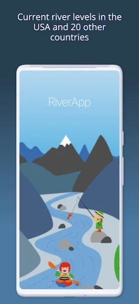
Get quick access to the latest water levels and river flows for rivers in the USA and 20 other countries around the world.
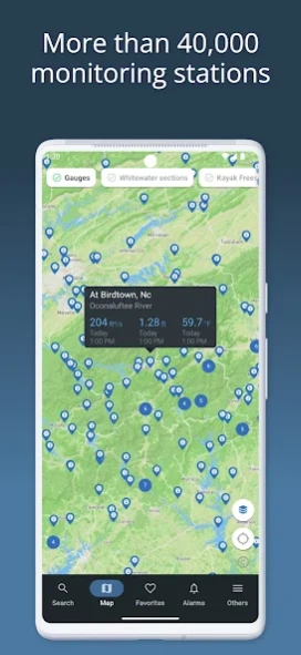
RiverApp is the application that contains data from the largest number of hydrometric stations in the world, with over 40,000 sites.
RiverApp is the ideal application for all river-related sporting or professional activities: kayaking, canoeing, pack rafting, stand-up paddling, fly fishing, river surfing, hydroelectricity, irrigation, etc.
It's also very useful for monitoring the evolution of rivers in the event of flooding.
FREE FEATURES:
‣ Current water levels and flows in over 15,000 rivers in the US and around the world.
‣ Water temperatures.
‣ Detailed maps of hydrometric stations and whitewater sections.
‣ Configuration of personalised alerts for each station when it has reached a defined value.
‣ Add stations or whitewater sections to favourites for immediate access to the latest readings and conditions.
FREE AND SPECIFIC FEATURES FOR WHITEWATER SPORTS:
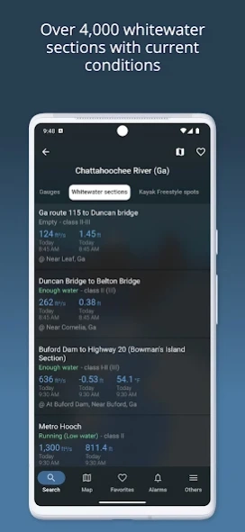
‣ More than 4000 referenced whitewater courses.
‣ Display of the navigability of courses according to water level or flow.
‣ Precise mapping of courses with quick access to put in and take out points.
‣ Display and publication of hazards (with photos) on routes.
‣ Information on the difficulty, length and average gradient of whitewater sections.
‣ Addition and modification of whitewater courses by the user community.
ADDITIONAL FEATURES WITH "RIVERAPP PREMIUM":
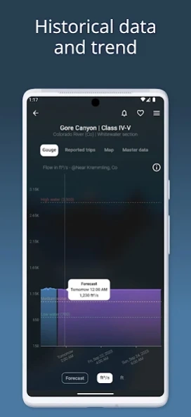
‣ History of water levels and flows up to several years back.
‣ Flow or water level forecasts at certain stations.
‣ Display and comparison of satellite images on maps from several providers.
SOURCES:
- NVE
- California Data Exchange Center
- Government of Canada (Wateroffice)
- USGS
- NOAA
- PEGELONLINE (www.pegelonline.wsv.de)
- HVZ Baden Württemberg
- HDN Bayern
- Kanton Bern
- Ennskraftwerke
- Land Kärnten
- Land Niederösterreich
- NVE
- Regione Piemonte
- HVZ RLP
- Český hydrometeorologický ústav
- HVZ Sachsen-Anhalt
- Land Salzburg
- Scottish Environment Protection Agency
- Slovak hydrometeorological institute
- Agencija Republike Slovenije za okolje
- HWZ Steiermark
- BAFU
- HNZ Thüringen
- Land Tirol
- Shoothill
- Vigicrue
- Serveur de données hydrométriques temps réel du bassin Rhône Méditerranée
- Land Vorarlberg
- Bureau of Meteorology (Australia)
RiverApp and the listed organizations are not liable for any errors or omissions in the Information and shall not be liable for any loss, injury or damage of any kind caused by its use.
Previous Versions
Here you can find the changelog of RiverApp - River levels since it was posted on our website on 2016-10-13 23:39:48.
The latest version is 5.11.0 and it was updated on 2024-04-01 17:40:46. See below the changes in each version.
RiverApp - River levels version 5.11.0
Updated At: 2024-03-27
Changes: Average flows, heights and temperatures displayed for many stations.
RiverApp - River levels version 5.10.3
Updated At: 2024-02-23
Changes: Bug fixes
RiverApp - River levels version 5.10.2
Updated At: 2023-12-17
Changes: -> It is now possible to add and display POI/features such as permanent hazards, alternative put in, parking, rapids on a whitewater section with pictures.
-> Several speed and UI improvements, especially on the map.
-> Several bug fixes
RiverApp - River levels version 5.9.0
Updated At: 2023-10-03
Changes: -> General improvement of the user interface and bug fixes
-> Add length of whitewater sections, gradient and total gradient
-> The app is now available in two new languages: Czech and Norwegian.
RiverApp - River levels version 5.8.0
Updated At: 2023-08-31
Changes: Improvements to river mapping with the ability to compare satellite views from several suppliers (Premium users)
RiverApp - River levels version 5.6.3
Updated At: 2023-08-04
RiverApp - River levels version 5.6.2
Updated At: 2023-08-01
Changes: The map of gauging stations and kayak sections has been completely re-implemented.
RiverApp - River levels version 5.5.0
Updated At: 2023-06-27
Changes: It is now possible to add manual station levels directly in the app
RiverApp - River levels version 5.3.0
Updated At: 2023-05-14
Changes: Overall performance improvement
RiverApp - River levels version 5.2.0
Updated At: 2022-05-16
Changes: The App now supports deep links for direct access to rivers, gauges or whitewater sections from external links.
Disclaimer
Official Google Play Link
We do not host RiverApp - River levels on our servers. We did not scan it for viruses, adware, spyware or other type of malware. This app is hosted by Google and passed their terms and conditions to be listed there. We recommend caution when installing it.
The Google Play link for RiverApp - River levels is provided to you by apps112.com without any warranties, representations or guarantees of any kind, so access it at your own risk.
If you have questions regarding this particular app contact the publisher directly. For questions about the functionalities of apps112.com contact us.